Fuel for thought
Published over 11 years ago. See the latest and most current information on Fuel for thought.
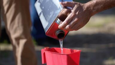
Experts estimate that there are billions and billions of barrels’ worth of untapped oil reserves located off the shores of our coastlines. In the Atlantic continental shelf alone, bordering the south-eastern part of the United States, scientists predict there is anywhere between 1.3 and 5.6 billion barrels’ worth of the black stuff. But how can we locate it?
The most popular and widespread method of detecting oil reserves at sea is using seismic mapping. This is achieved via the use of air-guns, which send sonic blasts of up to 250 decibels underwater, and then use the subsequent reverberations to map out the terrain. The sound waves will return to the ultra-sensitive sensors, depending on the distance, placement and density of the rock formation. From this data, scientists are able to extrapolate the whereabouts of likely underwater oil reserves. Indeed, in July of this year, the Obama administrated signed off on widespread seismic testing.
One less common and outdated alternative to using an air-gun is the use of explosives thrown overboard, which create similar sonic waves but have obvious undesirable consequences for the surrounding fauna and flora (although air-guns have also come under scrutiny for this same accusation).
Other methods of oil reserve location include studying surface rocks, soil samples and formations and applying this information to the subsurface formations. This had traditionally been done by manually collecting samples, which could be a painstaking and even dangerous undertaking. More recently, satellite technology and imagery has been used to achieve the same effect without the unnecessary risks. And earlier this year, science took another innovative step towards solving the problem.
This came in the shape of unmanned drones, of a similar model that Amazon hope will one day deliver their packages worldwide. The drones are part of a study undertaken by the universities of Aberdeen in Scotland and Bergen in Norway as an attempt to reach previously inaccessible areas of rock, which could yield valuable information about subsurface reservoirs. It is particularly useful when attempting to map unknown terrain between two different oil wells, which can be up to 2 miles apart at times and as such, difficult to envisage. For more information on such exciting developments, read this article: Unmanned Drones Used to Identify North Sea Oil Reserves.
Another unusual method of detecting oil which has become possible thanks to the advancement of science is by “sniffing” out the hydrocarbon formations using sensitive electronic “noses”. In addition to this, gravity meters which are capable of detecting even minor fluctuations in the Earth’s gravitational field can be employed to estimate where flowing oil may have affected the field. Similarly, magnetometers are able to detect subtle changes in the Earth’s magnetic field caused by the same occurrence.
PIN 27.3 June/July 2026