Fuel for Thought
Targeting in on Geosteering – The Basics Discussed
Aug 28 2014
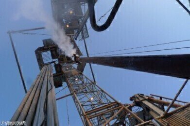
When creating the wellbore of an oil well, it is essential that the drill be positioned above the oil reservoir at all times. Due to the pressure and movement created by the act of drilling and the seismic shifts around the drillhead, such a feat can be hard to achieve. However, thanks to advances in technology, that feat has become more achievable with the advent of geosteering. So what is goesteering exactly? And how does it work?
Goesteering is the process of continually adjusting the placement of the drillhead to adapt to information gathered from the area around and below the drill in real time. Doing so can be a challenging task for the driller, since he is constantly being required to make decisions and react to data in real time, but ultimately, when done correctly, geosteering results in a better placed rig, which means less oil wastage and increased cumulative oil recovery.
How Does Geosteering Work?
Geosteering begins even before the oil rig is built. This will take the form of surveys, imaging studies and 2D and 3D projections of the terrain around the oil reservoir, as well as extensive seismic testing to ascertain how viable drilling on the chosen site will be. Test wells may also be drilled in the area to perform tests upon the underground conditions. From this collated data, the drilling team will be able to effectively plan the site, down to where and how to position the drill to achieve the best possible results. Factors they will take into account include the position and size of the reservoir and the possibility of needing fluid or gas injection.
Once the drill has been successfully planned, the drilling on the borehole will commence. However, conditions on the surface surrounding the projected borehole can change rapidly and abruptly and as such, ongoing data monitoring is required. This takes the shape of mud logging, measurement while drilling (MWD) and logging while drilling (LWD). These are achieved by collecting sample cuttings of rock, mineral and gas around the drillhead. These samples are collected and analysed using a variety of machinery and equipment, which is constantly evolving as technology advances. One example is a portable infrared analyser, which can be operated on-site and are discussed more fully in the article, Measurement of Hydrocarbons in Drilling Mud and Oil in Water, and can be very useful in successful mud logging and geosteering.
Geosteering can be a time-consuming process and one that is very challenging, both physically and mentally. It requires workers to remain on-site throughout the drilling process to ensure that they can interpret the data being sent to them and react quickly and effectively. Computer programmes may be able to help with the assimilation of the data and with advice on how to proceed - however, it will be up to the workers on site to physically put the input into practice. This level of dedication and effort is necessary, since drilling an oil well is invariably a costly practice and geosteering can help to maximise efficiency and production output.


Digital Edition
PIN 25.1 Feb/March
March 2024
In This Edition Safety - The technology behind the ION Science Tiger XT - Safety with ammonia and LOHCs as hydrogen carriers Analytical Instrumentation - Discussion on new tribology te...
View all digital editions


Events
Apr 22 2024 Hannover, Germany
Apr 22 2024 Marrakech, Morroco
Apr 22 2024 Muscat, Oman
Apr 22 2024 Rotterdam, Netherlands
Apr 23 2024 Singapore